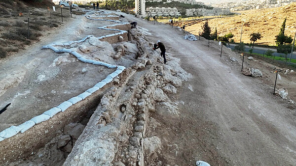
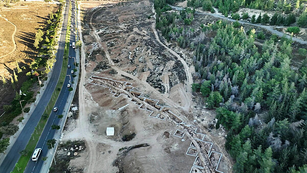
Archaeologists from the Israel Antiquities Authority (IAA) have exposed a 300-metre section of Jerusalem's Lower Aqueduct on the southern slopes below Kibbutz Ramat Rachel, in an area set aside for future residential development. The find was announced on 11 October 2026 and is being presented for the first time this week at the 19th annual conference New Studies in the Archaeology of Jerusalem and Its Region, held in Jerusalem and Tel Aviv by the IAA together with Tel Aviv University and the Hebrew University.
For our community, this is news from next door. The excavation lies only a short way across the valley from our hill on the Hebron Road.
Jerusalem was fed by two parallel aqueducts from Solomon's Pools. The higher of the two, the Upper Aqueduct, passed Rachel's Tomb and followed the old Jerusalem–Bethlehem road northward, running by the Mar Elias Monastery, just across the Hebron Road from Tantur, before continuing west of Ramat Rachel. The Lower Aqueduct, whose newly exposed stretch made the news this week, wound through Bethlehem and around the hills to the east. The ancient water supply of the Holy City, in other words, flowed on both sides of our hill.
A water line between Bethlehem and Jerusalem
The Lower Aqueduct is thought to have been built around 100 BCE. Jerusalem has always struggled for water: rainfall and the Gihon Spring (also known as the Virgin's Fountain, or ʿAin Umm ed-Daraj in Arabic) could not sustain the city alone, least of all when its population swelled with pilgrims at the great festivals. The solution was to bring water some 21 kilometres from the springs at Solomon's Pools, south of Bethlehem, to the Holy Sanctuary.
Its course therefore ran through the very terrain around us, linking the two cities that frame our life here. Generations of pilgrims travelling between Bethlehem and Jerusalem would have passed close to this channel, and drunk from the water it carried.
Background: a water system 68 kilometres long
The Lower Aqueduct was only one part of a much larger network. Feeder channels brought water to Solomon's Pools from springs in Wadi al-'Arrub, north of Hebron, along an aqueduct of about 45 kilometres, and from Wadi el-Biyar, through a tunnel some three kilometres long pierced by dozens of vertical shafts. The three great pools in the Artas valley, stepped down the slope one below another, hold roughly 288,000 cubic metres between them and served as the system's regulating reservoir. From there three conduits set out: the Lower and Upper Aqueducts to Jerusalem, and a third to Herod's palace-fortress at the Herodion, on the horizon south-east of Bethlehem.
The Lower Aqueduct is a feat of patience rather than force. Solomon's Pools lie only about ten kilometres from the Holy Sanctuary as the crow flies, yet the channel winds for more than 21 kilometres, hugging the contour lines to keep its gentle fall. Where a ridge could not be skirted, it went through it: a tunnel of some 360 metres under Bethlehem, and another of about 420 metres beneath today's Governor's Hill promenade, dug with the help of vertical shafts up to about 45 metres deep. Its destination was the network of more than thirty cisterns beneath the Holy Sanctuary.
Two aqueducts, two destinies
The Upper Aqueduct, about 13 kilometres long, was the more ambitious work. It supplied the higher, western part of the city and used refined techniques, including a stretch of interlocking perforated stone pipes forming an inverted siphon that carried water across a valley under pressure. Excavations at al-Tabaliya, today's Givat HaMatos settlement, a little further north, exposed about 300 metres of it in 2023, including repairs carried out by soldiers of Rome's Tenth Legion after the destruction of the city in 70 CE. Yet it fell out of use by late antiquity, while the humbler Lower Aqueduct kept flowing for another millennium and more.
Who built the system is still debated. The IAA attributes the Lower Aqueduct to the Hasmonean kings, around 100 BCE; other scholars, among them the authors of a recent UNESCO dossier, place its earliest phase in the late first century BCE, during the building programme of Herod the Great. The first-century historian Flavius Josephus also records that the Roman governor Pontius Pilate provoked an uproar by paying for an aqueduct to Jerusalem out of the Temple treasury, a project many scholars connect with one of these lines.
Simple engineering, remarkable precision
This was not an aqueduct of soaring arches like those at Caesarea or in Italy. According to excavation director Benyamin Storchan, it is a modest structure: two parallel rows of stone enclosing a plastered, U-shaped channel, probably once roofed with stone slabs.
What makes it extraordinary is its precision. From start to finish the total drop in height is only about 30 metres, and along most of the route the channel falls roughly one metre per kilometre, with the water moving by gravity alone. Where hills stood in the way, engineers cut tunnels rather than lose their gradient by going around. Access points along the route allowed workers to clear blockages. At the newly exposed section, the builders also plastered the outer face and pressed small stones into it while it was still wet, giving the wall a distinctive finish.
The IAA's Jerusalem District Archaeologist, Amit Re'em, described it as "an engineering marvel."
Two thousand years of service
Remarkably, the Lower Aqueduct remained in use, on and off, until about a century ago, maintained in turn by Roman, Byzantine, Early Islamic, Mamluk and Ottoman rulers. In the early 14th century the Mamluks rebuilt the channel's final stretch near the Old City along the ancient route, and the Ottomans repaired the pools and set up a dedicated endowment (waqf) to pay for the system's upkeep; the name "Solomon's Pools" is often linked to Sultan Suleiman the Magnificent. To protect the water, ceramic pipes were later laid inside the open channel (the IAA dates this to roughly 500 years ago, while other sources cite Ottoman works in 1786), and iron pipes followed on the Bethlehem–Jerusalem stretch in 1889. Only under the British Mandate did pumps and steel pipelines make the gravity-fed line redundant. In Arabic, the Lower Aqueduct is known as Qanat es-Sabeel, after the public fountains (sabeels) it once fed in the Old City.
Although the Upper Aqueduct was the more sophisticated of the two, it was the simpler Lower Aqueduct that outlasted it by roughly a thousand years. Excavation director Benyamin Storchan credits this to the skill of its original surveyors, who worked with simple calculations but chose their route with great care.
The excavators, Storchan together with Gil Freid and Rotem Cohen, are now studying how the system was maintained, repaired and adapted across the centuries. Freid is also using high-precision satellite positioning to reconstruct the aqueduct's exact path through southern Jerusalem, which will help researchers trace the route where modern building has erased it. Only about two of its 21 kilometres have been excavated so far.
Sources: Israel Antiquities Authority announcement of 11 October 2026, as reported by Haaretz, The Times of Israel, Ynet, Srugim, Kipa, JNS and TPS; earlier IAA reports on aqueduct finds at Givat HaMatos, Armon HaNatziv and Umm Tuba; UNESCO World Heritage Centre, Tentative List entry "Jerusalem water system: Qanat es-Sabeel" (2026).